


Bill Barrell Ltd
Bill Barrell Ltd
Po Box 10494
Grantham
Lincolnshire
NG31 0HS
United Kingdom
Phone: 01476 594698
Bill Barrell Ltd
Lot 129517
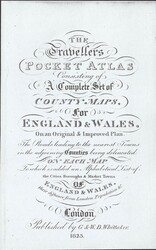
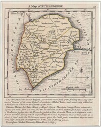
1823 MAP OF RUTLANDSHIRE BY NEELE AND SON. A fine 1823 map ...more
1823 MAP OF RUTLANDSHIRE BY NEELE AND SON. A fine 1823 map of
Rutlandshire (181 x 149) with fine colouring, vertical fold as
always as from 'The Travellers Pocket Atlas' published by Whittaker
in 1823. (Ref 129517)
Bill Barrell Ltd
Lot 129640
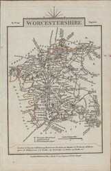
1759 MAP OF RUTLANDSHIRE BY JOHN GIBSON. A fine map of ...more
1759 MAP OF RUTLANDSHIRE BY JOHN GIBSON. A fine map of Rutlandshire
(90 x130) within card mounts by John Gibson, printed in 1759 and
published in his 'New and Accurate Maps of the Counties of England
and Wales'. Scarcer map. (Ref 129640)
Bill Barrell Ltd
Lot 74470
1812 NORTHAMPTONSHIRE MAP. A finemap (108 x 164) engraved ...more
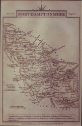
1812 NORTHAMPTONSHIRE MAP. A finemap (108 x 164) engraved and
published by John Cary in 1812. (Ref 74470)
Bill Barrell Ltd
Lot 131862
1792 MAP OF HEREFORDSHIRE AND ON REVERSE HERTFORDSHIRE BY CARY.
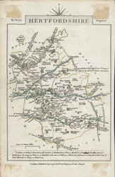
Fine ...more 1792 MAP OF HEREFORDSHIRE AND ON REVERSE HERTFORDSHIRE BY CARY. Fine maps of Herefordshire and Hertfordshire, 1792 printing by Cary in black on white wove paper (162 x 104). (Ref 131862).
Fine ...more 1792 MAP OF HEREFORDSHIRE AND ON REVERSE HERTFORDSHIRE BY CARY. Fine maps of Herefordshire and Hertfordshire, 1792 printing by Cary in black on white wove paper (162 x 104). (Ref 131862).
Bill Barrell Ltd
Lot 129370
1751 MAP OF RUTLAND BY KITCHIN AND JEFFERY. A very fine example ...more
1751 MAP OF RUTLAND BY KITCHIN AND JEFFERY. A very fine example of
the 1751 map of Rutlandshire by Kitchin and Jeffery, printed area
approximately 135 x 174mm with part hand colour. A scarce map which
originally appeared in 'The Small English Atlas' by Kitchin and
Jeffery with interesting topographical information at foot of map.
(Ref 129370)
Bill Barrell Ltd
Lot 134314
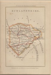
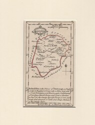
1835 MAP OF 'RUTLANDSHIRE' BY J B NICHOLS. Map of Rutlandshire, ...more
1835 MAP OF 'RUTLANDSHIRE' BY J B NICHOLS. Map of Rutlandshire, 112 x 168, mounted on card, 192 x 241, published by J B Nichols in 1835, several tone spots. (Ref 134314)
Bill Barrell Ltd
Lot 131863
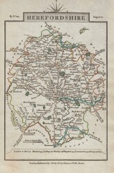
1806 MAP OF HEREFORDSHIRE BY CARY. A very fine 1806 map ...more
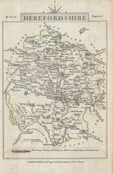
1806 MAP OF HEREFORDSHIRE BY CARY. A very fine 1806 map of
Herefordshire by Cary in black on white wove paper, slight pastel
colouring (104 x 160). (Ref 131863).
Current Time: Saturday July 13th 2024 - 19:08 MET