


Nordphila e.K.
Lot 4776
Mi
(13x20)
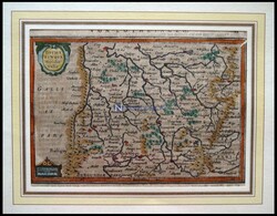
Lothringen, "Lotharingia Meridionalis", kolorierter Kupferstich ...more
Lothringen, "Lotharingia Meridionalis", kolorierter Kupferstich von
Janssonius um 1630
Automatically generated translation:
Lorraine, "Lotharingia Meridionalis", coloured copper engraving by Janssonius about 1630
Automatically generated translation:
Lorraine, "Lotharingia Meridionalis", coloured copper engraving by Janssonius about 1630
90.00 EUR
09/04/2024 23:59 CEST
Nordphila e.K.
Lot 4969
Mi
(31x25)
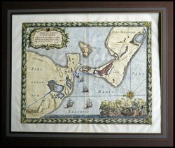
"Korsör" auf Seeland, sehr dekorative Ansicht mit Grundrißplan der ...more
"Korsör" auf Seeland, sehr dekorative Ansicht mit Grundrißplan der Stadt und neuer Citadelle (zur Beschützung des Hafens) sowie umliegender Gegend - im Vordergrund Segelschiffe und kleine Schlachtenszenerie, Anno 1659, kolorierter Kupferstich von Pufendorf aus "Sieben Bücher von denen Thaten Carl Gustavs Königs in Schweden" 1697
Automatically generated translation:
"Korsör" on Zealand, very decorative view with ground plan of the town and new Citadelle (to the protection of the Harbor) as well surrounding area - in the foreground sail ships and small Battle scenery, in the year of 1659, coloured copper engraving by Pufendorf from "seven books of these deeds Carl Gustavs king in Sweden" 1697
90.00 EUR
10/07/2024 14:00 CEST
Nordphila e.K.
Lot 4963
Mi
(32x39)
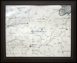
"Lauenförde", die Gegend von Warburg bis Lauenförde, Kupferstich ...more
"Lauenförde", die Gegend von Warburg bis Lauenförde, Kupferstich von Papen, 1862
Automatically generated translation:
"Lauenförde", the area from Warburg to Lauenförde, copper engraving by Papen, 1862
Automatically generated translation:
"Lauenförde", the area from Warburg to Lauenförde, copper engraving by Papen, 1862
50.00 EUR
10/07/2024 14:00 CEST
Nordphila e.K.
Lot 5108
Mi
(40x59)
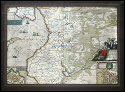
Dithmarschen, südlicher Teil, "Dithmarsiae pars Australis", mit ...more
Dithmarschen, südlicher Teil, "Dithmarsiae pars Australis", mit Grundrißplänen von Brunsbüttel und Meldorf, kolorierter Kupferstich von J. Meier aus Blaeu, 1662
Automatically generated translation:
Dithmarschen, southern part, "Dithmarsiae pars Australis", with map of the house from Brunsbüttel and Meldorf, coloured copper engraving by J. Meier from Blaeu, 1662
Automatically generated translation:
Dithmarschen, southern part, "Dithmarsiae pars Australis", with map of the house from Brunsbüttel and Meldorf, coloured copper engraving by J. Meier from Blaeu, 1662
300.00 EUR
06/30/2024 12:00 CEST
Nordphila e.K.
Lot 5111
Mi
(46x50)
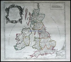
Großbritannien und Irland, "Britannicae Insulae", grenzkolorierter ...more
Großbritannien und Irland, "Britannicae Insulae", grenzkolorierter Ku- St. von Robert du Vaugondy aus Atlas universel, 1788
Automatically generated translation:
Great Britain and Ireland, "Britannicae Insulae", boundaries contemporary coloured Ku St. From Robert you Vaugondy made of atlas universel, 1788
Automatically generated translation:
Great Britain and Ireland, "Britannicae Insulae", boundaries contemporary coloured Ku St. From Robert you Vaugondy made of atlas universel, 1788
100.00 EUR
06/30/2024 12:00 CEST
Nordphila e.K.
Lot 4966
Mi
(46x56)
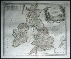
Postroutenkarte von Großbritannien und Irland, "Carte des Grandes ...more
Postroutenkarte von Großbritannien und Irland, "Carte des Grandes Routes"
Automatically generated translation:
Postal route map from Great Britain and Ireland, "Carte of the Grandes Routes"
Automatically generated translation:
Postal route map from Great Britain and Ireland, "Carte of the Grandes Routes"
100.00 EUR
10/07/2024 14:00 CEST
Nordphila e.K.
Lot 4777

Mi
(46x56)
Postroutenkarte von Großbritannien und Irland, "Carte des ...more
Postroutenkarte von Großbritannien und Irland, "Carte des Grandes
Routes"
Automatically generated translation:
Postal route map from Great Britain and Ireland, "Carte of the Grandes Routes"
Automatically generated translation:
Postal route map from Great Britain and Ireland, "Carte of the Grandes Routes"
100.00 EUR
09/04/2024 23:59 CEST
Nordphila e.K.
Lot 4977
Mi
(46x57)
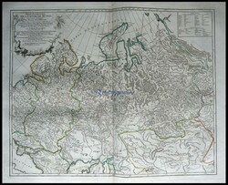
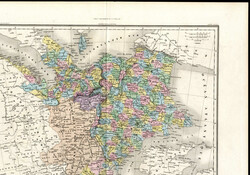
der westliche Teil von Rußland, "Partie Occidentale de L`Empire de ...more
der westliche Teil von Rußland, "Partie Occidentale de L`Empire de
Automatically generated translation:
The western part from Russia, "lot Occidentale de L`Empire de
Automatically generated translation:
The western part from Russia, "lot Occidentale de L`Empire de
90.00 EUR
10/07/2024 14:00 CEST
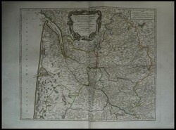
Nordphila e.K.
Lot 4774
Mi
(46x57)
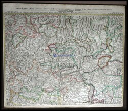
Rheinverlauf (Unterrheingegend) bei Köln und der ...more
Rheinverlauf (Unterrheingegend) bei Köln und der Moselgegend,
"Cursus Rheni auf Basilea usque ad Bonnam (sectio seu Inferior),
altkolorierter Kupferstich von Homann ca. 1750
Automatically generated translation:
Course of the Rhine (Unterrheingegend) by Cologne and the Moselle area, "Cursus Rheni on Basilea usque ad Bonnam (sectio seu Inferior), original coloured copper engraving by Homann approximate 1750
Automatically generated translation:
Course of the Rhine (Unterrheingegend) by Cologne and the Moselle area, "Cursus Rheni on Basilea usque ad Bonnam (sectio seu Inferior), original coloured copper engraving by Homann approximate 1750
210.00 EUR
09/04/2024 23:59 CEST
Nordphila e.K.
Lot 4793
Mi
(46x57)
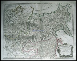
der östliche Teil von Rußland, "Partie Orientale de L`Empire ...more
der östliche Teil von Rußland, "Partie Orientale de L`Empire de
Russie
Automatically generated translation:
The eastern part from Russia, "lot oriental de L`Empire de Russia
Automatically generated translation:
The eastern part from Russia, "lot oriental de L`Empire de Russia
100.00 EUR
09/04/2024 23:59 CEST
Nordphila e.K.
Lot 5118
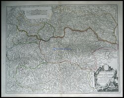
Mi
(46x59)
die nördliche Teil von Österreich, "Partie Septentrionale du Cercle ...more
die nördliche Teil von Österreich, "Partie Septentrionale du Cercle
Automatically generated translation:
The northern part from Austria, "lot Septentrionale you Cercle
Automatically generated translation:
The northern part from Austria, "lot Septentrionale you Cercle
100.00 EUR
06/30/2024 12:00 CEST
Nordphila e.K.
Lot 4976

Mi
(46x59)
die nördliche Teil von Österreich, "Partie Septentrionale du Cercle ...more
die nördliche Teil von Österreich, "Partie Septentrionale du Cercle
Automatically generated translation:
The northern part from Austria, "lot Septentrionale you Cercle
Automatically generated translation:
The northern part from Austria, "lot Septentrionale you Cercle
90.00 EUR
10/07/2024 14:00 CEST
Nordphila e.K.
Lot 5114
Mi
(50x60)
die Provinzen "Le Bourdelois, Le Perigord, L`Agenois, Le Bazadois", ...more
die Provinzen "Le Bourdelois, Le Perigord, L`Agenois, Le Bazadois", altkolorierter Kupferstich von Gilles Robert de Vaudondy, Atlas Univers. Paris 1757/8
Automatically generated translation:
The provinces "Le Bourdelois, Le Perigord, L`Agenois, Le Bazadois", original coloured copper engraving by Gilles Robert de Vaudondy, atlas Univers. Paris 1757 / 8
Automatically generated translation:
The provinces "Le Bourdelois, Le Perigord, L`Agenois, Le Bazadois", original coloured copper engraving by Gilles Robert de Vaudondy, atlas Univers. Paris 1757 / 8
180.00 EUR
06/30/2024 12:00 CEST
Viennafil Auctions
Lot 2077
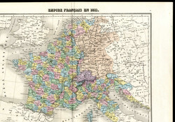

1811, kolorierte Landkarte des französischen Imperiums in ...more
1811, kolorierte Landkarte des französischen Imperiums in Jahre
1811, imp.ie Mignon 11, Rue du Moulin Vert, Paris; einwandfrei
erhalten
Automatically generated translation:
1811, coloured map of the French Empire in years 1811, imp. Ie minion 11, Rue you Moulin Vert, Paris; perfect quality
Automatically generated translation:
1811, coloured map of the French Empire in years 1811, imp. Ie minion 11, Rue you Moulin Vert, Paris; perfect quality
Teutoburger Münzauktion GmbH
Lot 6891
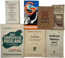
17 diverse alte Landkarten. U.a. Bielefeld Stadtplan, ...more
17 diverse alte Landkarten. U.a. Bielefeld Stadtplan, "Der
Nordseeraum und Westeuropa mit Westwall und Maginot-Linie", viele
Wanderkarten, usw. unterschiedlich erhalten
Automatically generated translation:
17 various old maps. U. On Bielefeld city map, "the North Sea Region and Western Europe with Siegfried Line and Maginot line", many hiking maps, and so on. Different condition
Automatically generated translation:
17 various old maps. U. On Bielefeld city map, "the North Sea Region and Western Europe with Siegfried Line and Maginot line", many hiking maps, and so on. Different condition
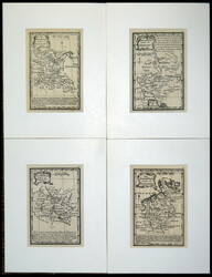
Nordphila e.K.
Lot 5107

Atlas Minimus Illustratus by J. Gibson/E. Bowen: 4 kleine ...more
Atlas Minimus Illustratus by J. Gibson/E. Bowen: 4 kleine Generalkarten von Deutschland, 1774, Kupferstiche
Automatically generated translation:
Atlas Minimus Illustratus by J. Gibson / E. Bowen: 4 small general maps from Germany, 1774, copper engravings
Automatically generated translation:
Atlas Minimus Illustratus by J. Gibson / E. Bowen: 4 small general maps from Germany, 1774, copper engravings
120.00 EUR
06/30/2024 12:00 CEST
Auction Galleries Hamburg
Lot 3350 D
Süd-Ost-Europa, schöne gerahmte Karte, wohl frühes 19.Jahrhundert, ...more
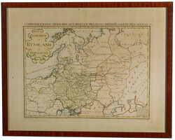
Süd-Ost-Europa, schöne gerahmte Karte, wohl frühes 19.Jahrhundert, "Allgemeine Postkarte von Russland zur Übersicht", mit Darstellung von u.a. Skandinavien, Baltikum, "Archangelske Statthalterei", "Neu-Russland", "Land der Donischen Kosaken". "Gestochen von Ignaz Kühn. Zu finden im von Reillyischen Landkarten und Kunstwerke Verschleiss Komtoir in Wien". (M)
Automatically generated translation:
South east Europe, nice framed card, seeming early 19th century, "generally postcard from Russia to the survey", with representation from among others Scandinavia, Baltic States, "Archangelske governors office", "new Russia", "country the Donischen Cossacks". "pricked from Ignatius Kühn. To find in the from Reillyischen maps and work of art attrition Komtoir in Vienna". (M)
100.00 EUR
07/21/2024 12:00 CEST
Auction Galleries Hamburg
Lot 3352 D+
7 more pictures.
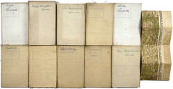
1740-1760, Gruppe von 21 großen Kupferstich-Landkarten und sieben ...more
1740-1760, Gruppe von 21 großen Kupferstich-Landkarten und sieben Poliometria (Tabellen mit Reisedistanzen) von deutschen Provinzen, Herzogtümern und Königreichen wie Preußen (mit Bildnis von König Friedrich Wilhelm I.), Brandenburg, Mecklenburg, Sachsen, Thüringen, Westfalen, Schlesien, etc. Die Karten wurden entworfen und gestochen von Matthäus Seutter, Kartograph und Verleger aus Augsburg (1678-1757), mit verzierten Kartuschen, auf schwerem Büttenpapier mit Blanko-Rückseiten, auf denen zeitgenössisch jeweils der Kartentitel in Handschrift verzeichnet wurde. Die Karten in verschiedenen Größen bis 60 x 50 cm. Alle in neun zeitgenössischen, handgefertigten Reiseschubern, bemerkenswert frisch und schön. (S)
Automatically generated translation:
1740-1760, group from 21 large copper engraving maps and seven Poliometria (tables with Reisedistanzen) from German provinces, duchies and kingdoms like Prussia (with portrait from King Friedrich Wilhelm I. ), Brandenburg, Mecklenburg, Saxony, Thuringia, Westfalia, Silesia, and so on the cards were designed and pricked from Matthew Seutter, mapper and publisher from Augsburg (1678-1757), with adorned cartouches, on heavy hand made paper with unmailed backs, on which contemporary in each case the map title in handwriting indicates became. The cards in different sizes to 60 x 50 cm. All in nine contemporary, handmade Reiseschubern, outstanding fresh and nice. (S)
1200.00 EUR
07/21/2024 12:00 CEST
Auction Galleries Hamburg
Lot 3354 D
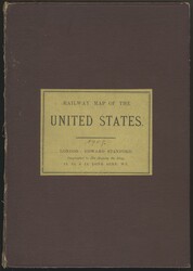
RAILWAY MAP OF THE UNITED STATES, aus dem Verlag STANFORD, London, ...more
RAILWAY MAP OF THE UNITED STATES, aus dem Verlag STANFORD, London, 1906, ausfaltbare große Karte (115 x 83 cm), auf Tuch aufgezogen, sehr informativ für den USA- und Bahnpostsammler auch mit kanadischen Bahnlinien, im Buchumschlag. Dieser am Rücken rechts etwas angetrennt, sonst gute Erhaltung. (S)
Automatically generated translation:
RAILWAY MAP OF THE UNITED STATES, from the publishing house STANFORD, London, 1906, foldout large card (115 x 83 cm), on cloth made up, very informative for the USA and railway post collector also with Canadian train lines, in the book cover. This at the move right a little separated, otherwise very fine. (S)
40.00 EUR
07/21/2024 12:00 CEST
Auction Galleries Hamburg
Lot 3351 D

Kleines Lot älterer Karten, u.a. um 1900 (?) Karte der R.O.P.I.T. ...more
Kleines Lot älterer Karten, u.a. um 1900 (?) Karte der R.O.P.I.T. (Russische Gesellschaft für Handel und Schifffahrt) Schwarzes Meer und Mittelmeer; desweiteren Alt-Italien, Europa, aber auch Singapur und Batavia. (M)
Automatically generated translation:
Small lot older cards, among others around 1900 (?) card the R. O. P. I. T. (Russian society for trade and navigation) Black Sea Arena and Mediterranean; furthermore old Italy, Europe, but also Singapore and Batavia. (M)
Automatically generated translation:
Small lot older cards, among others around 1900 (?) card the R. O. P. I. T. (Russian society for trade and navigation) Black Sea Arena and Mediterranean; furthermore old Italy, Europe, but also Singapore and Batavia. (M)
65.00 EUR
Sold
Auction Galleries Hamburg
Lot 3353 D
Lot Landkarten, u.a. "Carte des Postes 1808" von Deutschland, China ...more
Lot Landkarten, u.a. "Carte des Postes 1808" von Deutschland, China etc. Teils seltene Stücke, bitte ansehen! (M)
Automatically generated translation:
Lot maps, among others "Carte of the post office 1808" from Germany, China and so on partly scarce pieces, please take a look! (M)
Automatically generated translation:
Lot maps, among others "Carte of the post office 1808" from Germany, China and so on partly scarce pieces, please take a look! (M)
90.00 EUR
Sold
Kirstein-Larisch
Lot 2138
1895/1999, 55 Bücher/ Hefte/ Zeitschriften mit meist Kunst-/ Zeit- ...more
1895/1999, 55 Bücher/ Hefte/ Zeitschriften mit meist Kunst-/ Zeit- u. Weltgeschichte, dabei kl. Buch "Goethe's ausgewählte Werke", 5 verschied. Bände "Die Kunst dem Volke", 3 Bände "Volk u. Welt", 3 Bände "Die silbernen Bücher", 2 Bände Wilhelm v. Kügelgen "Jugenderinnerungen eines alten Mannes", 3 Bände U-Boot- Literatur, zusätzl. einige Landkarten
Automatically generated translation:
1895 / 1999, 55 books / booklets / periodicals with mostly Art / time and world history, as well small book "Goethe selected works", 5 various volumes "the art the peoples", 3 volumes "people and world", 3 volumes "the silver books", 2 volumes Wilhelm from Kügelgen "youthful memories of an old man", 3 volumes U boat literature, additional a few maps
Nordphila e.K.
Lot 4962
Atlas Minimus Illustratus by J. Gibson/E. Bowen: 4 kleine ...more
Atlas Minimus Illustratus by J. Gibson/E. Bowen: 4 kleine Generalkarten von Deutschland, 1774, Kupferstiche
Automatically generated translation:
Atlas Minimus Illustratus by J. Gibson / E. Bowen: 4 small general maps from Germany, 1774, copper engravings
Automatically generated translation:
Atlas Minimus Illustratus by J. Gibson / E. Bowen: 4 small general maps from Germany, 1774, copper engravings
100.00 EUR
10/07/2024 14:00 CEST
Bill Barrell Ltd
Lot 60098
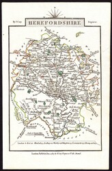
1817 HEREFORDSHIRE MAP. A fine 1817 map of Herefordshire by ...more
1817 HEREFORDSHIRE MAP. A fine 1817 map of Herefordshire by Cary.
(Ref 60098)
Bill Barrell Ltd
Lot 72199
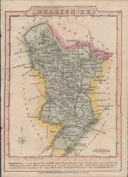
MAP/DERBYSHIRE. A very fine map by J.Wallis produced for his ...more
MAP/DERBYSHIRE. A very fine map by J.Wallis produced for his 1814
Travellers Companion pocket edition (102x140mm). Some pastel
colouring. (Ref 72199)
Current Time: Wednesday September 18th 2024 - 22:19 MET
